Table of Contents:
Germany's Most Iconic Scenic Routes: Romantic Road, Castle Road & Alpine Pass Highlights
Germany's network of designated scenic routes — known as Ferienstraßen — spans over 150 individual thematic roads, covering roughly 50,000 kilometers of curated driving experiences. Unlike the anonymous efficiency of the Autobahn, these corridors were deliberately designed to connect cultural heritage, natural landscapes, and regional identity into a single cohesive journey. For anyone serious about understanding what makes German road travel exceptional, three routes stand above the rest: the Romantic Road, the Castle Road, and the Alpine Road.
The Romantic Road: Germany's Most Visited Scenic Corridor
Stretching 460 kilometers from Würzburg in Franconia south to Füssen at the foot of the Alps, the Romantische Straße was established in 1950 and remains Germany's most commercially successful scenic route, attracting over 1 million visitors annually. The road passes through 29 towns and villages, with Rothenburg ob der Tauber consistently ranking as the must-stop highlight — its medieval walls, Plönlein half-timbered corner, and Christmas Market drawing visitors year-round. What many drivers overlook is the significant quality variation along the route: the northern stretches between Würzburg and Dinkelsbühl offer the most authentic, crowd-free experience, particularly in spring when the Tauber Valley turns green and the tour buses haven't arrived in force yet. Plan a minimum of three days to drive it properly; rushing the Romantic Road in a single day is the most common mistake first-timers make.
For a broader perspective on how Germany's scenic routes compare in character and driving quality, the most memorable driving experiences across Germany share one common trait: they reward patience and spontaneous detours far more than rigid itineraries do.
Castle Road and the Alpine Pass: Contrast at Its Best
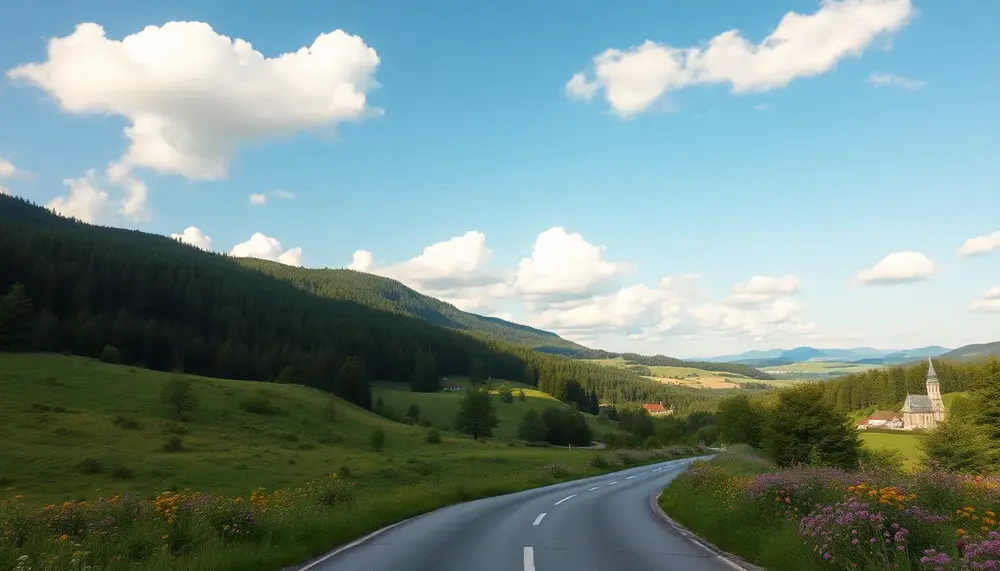
The Burgenstraße (Castle Road) runs 1,200 kilometers from Mannheim all the way to Prague, making it one of Europe's longest thematic routes. Within Germany, the 70-kilometer stretch between Heilbronn and Rothenburg packs the highest density of medieval fortifications per kilometer, including Burg Hornberg, Götzenburg, and the perfectly preserved Jagsthausen castle complex. Drivers who treat this as merely a sightseeing checklist miss the real value: the road traces the Neckar and Jagst river valleys, offering some of Baden-Württemberg's finest rural scenery between the castle stops.
The Deutsche Alpenstraße, running 450 kilometers from Lindau on Lake Constance to Berchtesgaden near the Austrian border, operates on an entirely different scale. Elevations regularly exceed 1,000 meters, and passes like the Kesselberg (900 meters) and Sudelfeld offer the kind of technical driving that no lowland route can match. The stretch around the Chiemsee and through the Berchtesgadener Land is frequently cited by experienced drivers as Germany's most visually dramatic road segment. The route demands respect in autumn — first snowfall on higher passes can occur as early as October.
Those looking to explore the full spectrum of Germany's landscape diversity will find that the most rewarding routes through Germany's countryside often connect these major corridors through lesser-known connecting roads that the standard tourist maps don't emphasize. Similarly, understanding the visual geography of Germany's most striking natural settings helps drivers make smarter decisions about timing and seasonal conditions before committing to a multi-day itinerary.
- Best season for Romantic Road: Late April to early June (before peak crowds, fields in bloom)
- Best season for Castle Road: September to October (harvest festivals, golden light, thin traffic)
- Best season for Alpine Road: July to mid-September (passes fully open, visibility at maximum)
Regional Route Diversity: From the Bavarian Alps to the North Sea Coastline
Germany's geographic diversity across roughly 357,000 square kilometers produces a remarkable spectrum of driving experiences that few European countries can match. The contrast between the jagged limestone peaks of the Berchtesgadener Land and the windswept tidal flats of the Wadden Sea coast isn't merely aesthetic — it translates directly into fundamentally different route characters, seasonal windows, and driving demands. Understanding this regional diversity is the foundation of any serious approach to planning scenic travel through the country.
Southern Germany: Alpine Drama and Romantic Valley Roads
Bavaria's alpine zone, concentrated in the strip south of Munich between Garmisch-Partenkirchen and Berchtesgaden, delivers the most technically demanding and visually intense driving in Germany. The Deutsche Alpenstraße — stretching 450 kilometers from Lindau on Lake Constance to Berchtesgaden — crosses 16 mountain passes and reaches elevations above 1,700 meters, requiring careful timing between late May and mid-October to avoid snow closures. The route passes directly through some of the landscapes that inspire many travelers to explore Germany's most visually rewarding terrain, with the Tegernsee and Chiemsee providing natural anchors along the way.
Moving north from the Alps, the Bavarian foothills transition into the pastoral romanticism of the Romantische Straße, Germany's oldest themed tourist route at 460 kilometers. Running from Würzburg south to Füssen, this corridor connects 29 towns including Rothenburg ob der Tauber — a fully intact medieval walled city that draws 2.5 million visitors annually. The route's success has inspired dozens of similar themed roads, but the original remains the benchmark for combining cultural density with genuine scenic quality.
Central and Northern Corridors: Forest, River, and Coast
The Rhine Valley between Rüdesheim and Koblenz represents Germany's most concentrated scenic driving corridor, packing over 40 castles, 130 wine villages, and dramatic cliff formations into just 65 kilometers of riverside road. The Loreley stretch near St. Goarshausen is frequently congested in summer, making early morning departures — before 8:00 AM — essential for unhurried photography stops. Drivers who have discovered these memorable routes along Germany's waterways consistently rate the section between Bacharach and Boppard as the visual highlight.
Heading north, the character shifts decisively. The Harzer Hochstraße through the Harz Mountains offers dense beech and spruce forest driving with the added intrigue of Germany's highest northern peak, the Brocken at 1,141 meters. Further north, the Schleswig-Holstein coast introduces an entirely different logic: flat, wide-open landscapes where the drama comes from enormous skies, lighthouse silhouettes, and the particular quality of North Sea light. Routes along the Nordseeküsten-Radweg corridor and the causeway to Sylt reward visitors who appreciate subtle, atmospheric beauty over Alpine spectacle.
For drivers wanting to systematically work through these regional contrasts, the most effective approach is to treat Germany's scenic network as a collection of distinct personalities rather than a single experience. The curves and contours found throughout the country's varied regions require different preparation:
- Alpine routes: Check pass opening dates via the ADAC website, carry snow chains May through June
- River valley roads: Avoid Rhine and Moselle routes on summer weekends; midweek travel cuts traffic by 40%
- Northern coastal roads: Plan around tidal schedules for causeway crossings to Halligen islands
- Forest routes (Harz, Black Forest): Best experienced in October for foliage or February for snow coverage
Pros and Cons of Driving Scenic Routes in Germany
| Pros | Cons |
|---|---|
| Beautiful landscapes and picturesque towns | Can be crowded during peak tourist seasons |
| Rich cultural heritage and historical landmarks | Some roads may have variable surface quality |
| Variety of scenic routes catering to different interests | Long driving distances between some attractions |
| Opportunities for spontaneous detours and exploration | Limited services and fuel stations in rural areas |
| Accessible for various travel styles: cars, motorcycles, campervans | Seasonal weather can impact road conditions |
Seasonal Strategy: Choosing the Right Time of Year for Each Scenic Corridor
Timing your drive along Germany's scenic corridors is not a matter of preference — it's a matter of strategy. The same road that delivers breathtaking vineyard panoramas in October can feel grey and underwhelming in February. Each of Germany's major scenic routes has a distinct seasonal peak, and experienced road travelers know that matching the corridor to the calendar separates a memorable journey from a mediocre one.
Spring and Summer: Alpine Roads and Northern Coastlines
The Deutsche Alpenstraße (German Alpine Road), stretching 450 kilometers from Lindau on Lake Constance to Berchtesgaden, reaches its absolute prime between late May and mid-July. Snow has retreated from the high passes, wildflowers carpet the meadows around Füssen and Garmisch-Partenkirchen, and visibility across the Zugspitze range regularly exceeds 80 kilometers. Avoid August if possible — tourist traffic through towns like Mittenwald can add 45 minutes to what should be a flowing mountain drive. Those who enjoy navigating roads that curve through dramatic elevation changes will find June the sweet spot before crowds and summer haze arrive simultaneously.
Germany's Baltic and North Sea coastal routes — particularly the B76 between Kiel and Lübeck and the Schleswig-Holstein shoreline roads — reward visitors between June and early September. The light quality at these latitudes during midsummer is genuinely exceptional, with golden-hour conditions lasting well past 9 PM. Wind conditions along the Frisian coast average 5–7 Beaufort in spring, which creates dramatic seascape photography opportunities but can make open-top driving uncomfortable.
Autumn: The Undisputed Peak Season for River Valleys and Wine Roads
If there is one season that defines scenic driving in Germany, it is autumn — specifically the window between late September and early November. The Mosel Valley, the Rhine Gorge between Bingen and Koblenz, and the Romantische Straße all undergo a visual transformation during this period that no other season replicates. Vineyard terraces turn copper and amber, harvest festivals bring authentic regional culture to small towns like Bernkastel-Kues and Rüdesheim, and the lower sun angle creates softer, more directional light throughout the day. Travelers exploring the layered visual character of Germany's river corridors and forested highlands consistently rate October as their most productive month for photography and overall experience.
The Schwarzwaldhochstraße (Black Forest High Road, B500) deserves special mention for its autumn foliage window, which typically peaks between October 10–25 depending on elevation. At 1,000 meters above sea level near Hornisgrinde, the beech forests shift color roughly two weeks earlier than the valleys below, giving strategic drivers the opportunity to catch both peaks within a single long weekend.
Winter driving on Germany's scenic routes is rarely discussed but can be genuinely rewarding for those prepared for it. The Fairy Tale Road (Märchenstraße) through Hesse and Lower Saxony takes on an entirely different character under snow, with half-timbered towns like Alsfeld and Bad Wildungen resembling the very storybooks they reference. Road conditions on the B3 corridor remain manageable with winter tires, and accommodation prices drop 30–40% compared to summer rates. Those planning a multi-day route through Germany's quieter interior landscapes will find winter weekdays offer an almost solitary experience that peak-season travel simply cannot deliver.
- Alpine Road: Late May to June (pre-crowd, post-snow)
- Mosel & Rhine Valley: Late September to late October (harvest and foliage)
- Baltic Coast roads: June to early September (light quality and temperatures)
- Black Forest High Road: October 10–25 (elevation-dependent foliage peak)
- Fairy Tale Road: January to February (snow scenery, minimal traffic)
Navigation, Signage & Road Infrastructure on German Panoramic Routes
Germany's panoramic routes operate on a well-established but often misunderstood signage system that rewards those who understand its logic. Unlike motorway navigation, these routes rely on brown directional signs — the universally recognized European color for tourist and cultural destinations. On flagship routes like the Romantic Road (Romantische Straße) or the German Alpine Road (Deutsche Alpenstraße), these brown signs appear at virtually every meaningful junction. However, coverage becomes inconsistent on lesser-known routes, and gaps of 15–30 kilometers between signs are not uncommon in rural Bavarian or Thuringian stretches.
Experienced drivers planning routes worth adding to their driving bucket list quickly learn that relying exclusively on roadside signage is a recipe for missed turns. The practical solution is layered navigation: carry a dedicated road atlas (ADAC's regional editions remain the gold standard), run a GPS device with offline maps loaded, and download the relevant route's GPX file from the official tourism association website before departure. The Deutsche Straßen der Romantik and similar route organizations publish free GPX data that captures detours, viewpoints, and seasonal road closures standard navigation apps simply don't flag.
Road Conditions and Infrastructure Realities
Surface quality varies dramatically by region and funding source. Federal scenic routes (Bundesstraßen designated as tourist routes) generally maintain higher standards — expect well-marked passing places and consistent lane widths of 3.0–3.5 meters. State-maintained stretches (Landesstraßen) tell a different story: sections of the Moselle Wine Route and parts of the Black Forest High Road include narrow passages where two standard vehicles can barely pass, and winter frost damage often goes unrepaired until late spring. Before tackling any mountain route between November and April, verify current road conditions through the BASt (Federal Highway Research Institute) portal or the state-specific Straßenzustandsbericht.
Fuel and service infrastructure follows predictable patterns that catch first-timers off guard. On the stretches that wind through the country's most spectacular back-country terrain, gaps between filling stations can exceed 60 kilometers — particularly on the Swabian Alb Route and the Eifel highlands sections. The rule of thumb: refuel whenever your tank drops below half, especially on weekends when rural stations close by early afternoon. EV drivers face additional challenges; fast-charging infrastructure along scenic routes lags motorway coverage by roughly five years, with Level 2 chargers (22 kW) being the realistic expectation outside of major waypoint towns.
Digital Tools and Official Route Resources
The most reliable digital resources are route-specific rather than generic:
- Komoot collections published by regional tourist boards include surface ratings and seasonal warnings unavailable on Google Maps
- OsmAnd with downloaded offline maps covers remote valleys where mobile data is genuinely absent
- The ADAC TourFinder app integrates fuel prices, parking areas rated for motorhomes, and current construction zones on all major scenic routes
- Local Verkehrsverbünde websites publish road closure calendars for autumn harvest festivals and cycling events that regularly close scenic roads on weekends
One infrastructure detail that distinguishes Germany from comparable European destinations: the Parkplatz mit Aussichtspunkt system. Formal viewpoint parking areas appear every 8–12 kilometers on well-managed routes, with standardized signage, often with informational panels explaining the landscape. These aren't afterthoughts — they're engineered into the route experience, and planning stops around them rather than improvised roadside parking significantly reduces both risk and friction with local traffic.
Historic Villages, Medieval Towns & Cultural Landmarks Along the Routes
Germany's scenic roads don't simply connect landscapes — they thread through more than 2,000 years of layered history. The country has over 2,300 officially protected historic town centers (historische Altstädte), many of which sit directly on or just minutes from the major scenic routes. Understanding which stops genuinely reward a detour — and which are overcrowded tourist traps — separates a memorable road trip from a frustrating one.
The Romantic Road and Its Medieval Core
The Romantische Straße remains Germany's most visited scenic route for good reason: it connects a near-unbroken chain of medieval towns across 460 kilometers from Würzburg to Füssen. Rothenburg ob der Tauber is the headline act — its 13th-century walls are 3.5 kilometers long and almost entirely walkable — but savvy travelers know to arrive before 9 a.m. or after 5 p.m. to avoid the 2.5 million annual visitors. Far less crowded and equally compelling is Dinkelsbühl, whose Late Gothic St. Georg Minster dates to 1448 and whose half-timbered market square has barely changed since the Thirty Years' War. Those exploring the country's most photogenic stretches of road consistently rank Dinkelsbühl among the top five authentic medieval experiences in Central Europe.
Further south, Nördlingen deserves a full half-day. The town sits inside a 15-million-year-old meteor crater (the Nördlinger Ries, roughly 25 km in diameter), and its 14th-century defensive wall is one of only three in Germany that can be walked in its entirety. The Daniel tower of St. Georg church offers a panoramic view that makes the geology genuinely visible — the entire crater rim appears as a subtle circular ridge on the horizon.
Castle Roads, River Towns and UNESCO Clusters
The Burgenstraße (Castle Road) runs 1,200 kilometers from Mannheim to Prague, passing more than 70 castles and palace complexes. Heidelberg anchors the western end with its partially ruined Renaissance castle — the largest in Germany before its 17th-century destruction — and a pedestrian old town that functions as a working university city rather than a museum piece. Drivers following Germany's most rewarding back-road itineraries often use Heidelberg as a launch point before heading east through Bad Wimpfen, a Roman imperial city with 13th-century Hohenstaufen palace ruins visible from the Neckar valley below.
Along the Mosel wine route, the towns follow a different architectural logic: narrow river gorges meant development stacked vertically rather than spreading outward. Cochem with its neo-Gothic Reichsburg castle (restored 1877, dramatically positioned 100 meters above the river) and Bernkastel-Kues with its 16th-century half-timbered market square are the standout stops. The latter also houses the Cusanus-Stift, a 1458 hospital and library founded by cardinal and philosopher Nicolaus of Cusa — a genuine intellectual landmark that most visitors walk past without recognizing its significance.
- Quedlinburg (Saxony-Anhalt): UNESCO World Heritage Site since 1994, with 1,300 half-timbered buildings concentrated in a single historic core — the highest density in Germany
- Regensburg: One of Europe's best-preserved medieval cities, with a Roman gate from 179 AD still standing on the main pedestrian axis
- Celle (Lower Saxony): 500 half-timbered houses and a ducal palace — largely unknown to international visitors despite being an exceptional example of Renaissance urban planning
The practical insight most travel guides omit: Germany's smaller historic towns — those with populations under 10,000 — often close their museum collections on Mondays and Tuesdays. Checking opening hours against your route calendar before departure prevents repeated disappointment. Anyone serious about making the most of Germany's great driving roads builds in at least one unplanned stop per day — the unmarked Romanesque chapel outside Lauda-Königshofen or the Roman villa ruins near Nennig reward exactly that kind of spontaneous detour.
Scenic Routes for Every Travel Style: Motorcycle, Campervan, Cycling & Hiking Alternatives
Germany's iconic scenic roads don't belong exclusively to car travelers. The same corridors that make the most memorable drives through Germany's countryside unforgettable also serve as the backbone for entirely different travel experiences — each with its own rhythm, gear list, and reward. Matching your travel style to the right route dramatically changes what you actually see and experience on the ground.
Motorcyclists: Where Asphalt Meets Altitude
For motorcyclists, the Deutsche Alpenstraße between Lindau and Berchtesgaden is the gold standard — 450 kilometers of sweeping curves, elevation changes up to 1,738 meters at the Sudelfeld pass, and road surfaces that reward experienced riders. The stretch between Oberjoch and Nesselwang alone features over 100 curves in under 15 kilometers. Riders planning multi-day tours should consider basing themselves in Garmisch-Partenkirchen or Reit im Winkl, both of which offer dedicated motorcycle parking, covered storage, and local route advice. The Schwarzwald-Hochstraße (B500) is a worthwhile northern alternative, with gentler gradients and better fuel stop spacing — roughly every 40 kilometers.
One practical rule for motorcyclists: avoid the Romantic Road and Fairy Tale Road in July and August. Campervan and bus traffic between Würzburg and Füssen slows the experience considerably. Instead, those touring routes shine in May or October when traffic thins and the light quality for photography improves significantly.
Campervans & Slow Travel
Germany's Wohnmobil infrastructure is among Europe's best. Over 3,500 designated Stellplätze (motorhome pitches) exist nationwide, with excellent concentration along the Moselle Valley, the Bavarian Alps, and the Mecklenburg Lake District. The Moselweinstraße between Trier and Koblenz — 242 kilometers through vine-covered slopes — has more than 25 riverside Stellplätze, many with electricity, water hookups, and direct vineyard access. Nightly costs typically range from €8 to €18. For those exploring the more serpentine stretches of Germany's route network, a vehicle under 7 meters handles mountain passes like the Ramsau or Berchtesgaden area far more comfortably than a full-length motorhome.
Cycling & Hiking: The Routes You Never See From a Car
The Elberadweg (Elbe Cycle Route) runs 1,260 kilometers from the Czech border to the North Sea, consistently rated one of Europe's top long-distance cycling routes. The section between Dresden and Magdeburg — roughly 290 kilometers — combines flat riverside terrain, UNESCO-listed Elbe Valley landscapes, and excellent cycling infrastructure with dedicated lane markings. Average completion time for this segment is 4 to 5 days at a relaxed touring pace.
Hikers have equally compelling options. The Westweg in the Black Forest stretches 285 kilometers from Pforzheim to Basel, traversing the highest peaks including the Feldberg at 1,493 meters. The route is well-marked with red diamond blazes and supported by a dense network of mountain huts. Those seeking shorter immersive experiences can join it at Titisee or Todtnau for 2 to 3 day segments. The landscapes encountered here — dense fir forest, open ridgelines, sudden valley panoramas — represent the kind of scenery that defines Germany's natural beauty at its most accessible.
- Best cycling months: May to September, with June offering optimal daylight and lower precipitation
- Campervan tip: Book Stellplätze along the Moselle and Rhine at least 48 hours ahead in summer
- Motorcycle priority: Early morning departure (before 8am) on Alpine routes avoids tourist traffic and delivers the best road conditions
- Hiking logistics: Westweg huts require advance reservation from April onwards — walk-ins are rarely possible on peak-season weekends
Practical Route Planning: Distances, Stopovers, Fuel & Accommodation Benchmarks
Experienced road-trippers know that the difference between a memorable journey and an exhausting ordeal comes down to planning density — specifically, how much ground you try to cover per day. On Germany's most rewarding scenic routes, a realistic benchmark is 150 to 220 kilometers per driving day, factoring in photo stops, village walks, and spontaneous detours. Push beyond 300 km and you'll spend more time behind the windshield than actually experiencing the landscapes you came for.
Key Distance and Stopover Benchmarks by Route Type
The Romantic Road (Romantische Straße) stretches approximately 460 km from Würzburg to Füssen — plan five to seven days if you want to engage meaningfully with towns like Rothenburg ob der Tauber, Dinkelsbühl, and Augsburg rather than just drive past them. The German Alpine Road (Deutsche Alpenstraße) covers roughly 450 km between Lindau and Berchtesgaden, but its serpentine mountain sections reduce average speeds to 40–60 km/h on many stretches. Build in a full rest day around Garmisch-Partenkirchen or Berchtesgaden — these aren't just scenic pauses but logistical necessities. For those exploring the most celebrated driving corridors across multiple regions, grouping routes by geographic cluster saves significant backtracking time.
Fuel planning requires more attention than most travelers anticipate. On rural scenic routes — particularly in the Eifel, the Sauerland, or the eastern Bavarian Forest — petrol stations can be 30 to 50 km apart. Never let your tank drop below a quarter on these roads. Diesel and E10 petrol are universally available; EV charging infrastructure has improved dramatically, but on remote alpine or forest routes you should pre-map charging stops using ADAC's eMobility app or Plugshare. A practical buffer: charge to 80% before entering any stretch longer than 120 km without a confirmed rapid charger en route.
Accommodation Strategy Along Scenic Corridors
Booking accommodation in popular gateway towns — Rüdesheim on the Rhine, Berchtesgaden, or Baden-Baden — requires lead times of four to eight weeks during peak season (June–September) and during events like the Oktoberfest fortnight. A smarter strategy: anchor your nights in second-tier towns that sit five to fifteen kilometers off the main tourist axis. These offer significantly lower rates (often 25–40% cheaper than the headline destinations) and frequently better food. Gasthäuser and Landhotels in villages like Altenahr, Mittenwald, or Waldkirch provide authentic regional experiences that chain hotels on the tourist trail simply cannot match.
For multi-week itineraries weaving through varied terrain from Rhine valley lowlands to alpine passes, a mixed accommodation approach works best: two nights in a characterful Landhotel followed by one night in a town center property where you can walk to restaurants and refuel the next morning without retracing your route. Budget realistically: mid-range accommodation along premium scenic routes runs €85–€140 per night double, breakfast included, outside Munich and Lake Constance where expect €120–€190.
One detail many guides overlook: parking in historic old towns is frequently restricted or paid-only, with many Altstädte having no overnight parking at all. Always confirm whether your hotel has private parking or a partner garage — in towns like Rothenburg, Bamberg, or Quedlinburg this is non-negotiable. Those planning to explore Germany's most dramatic and winding road segments should additionally check seasonal road closures, particularly on alpine passes like the Kesselberg or the Roßfeld-Ringstraße, which can be closed due to snow from November through April.
Off-the-Beaten-Path Scenic Drives: Germany's Lesser-Known Routes Worth Discovering
While the Romantic Road and the Black Forest's B500 attract millions of visitors annually, Germany's most rewarding drives often hide in plain sight. These overlooked corridors reward drivers with empty roads, authentic villages, and landscapes that haven't yet been optimized for Instagram. After years of exploring both the famous and the forgotten, the lesser-known routes consistently deliver the more memorable experiences.
Hidden Gems Beyond the Classic Tourist Circuits
The Deutsche Alleenstraße (German Avenue Road) stretches roughly 2,900 kilometers from Rügen in the north to the Bodensee in the south, threading through a canopy of mature linden, chestnut, and oak trees that predate the automobile by centuries. Many of these allées were planted under Prussian order in the 18th century to provide shade for marching troops — today they offer one of Germany's most distinctive driving experiences, particularly in autumn when the tunnels of color are genuinely spectacular. The Mecklenburg section between Güstrow and Waren is especially dense with intact avenues and sees a fraction of the traffic you'd encounter on more publicized routes.
The Hochsauerland Höhenstraße in North Rhine-Westphalia cuts through the Rothaargebirge at elevations between 600 and 800 meters, connecting the spa towns of Bad Berleburg and Winterberg across roughly 80 kilometers of rolling highland. This route is almost completely unknown to international visitors yet delivers sweeping views across the Sauerland's forested ridgelines, particularly stunning in early morning fog. The road surface quality is excellent, and the complete absence of tour buses makes it ideal for unhurried exploration.
- Eselsberg Route (Baden-Württemberg): A 35-kilometer loop around the Swabian Alb escarpment near Ulm, with dramatic limestone formations and medieval castle ruins that rival anything on the more famous Alb routes
- Odertal Panoramastraße (Harz): The valley road following the Oder River south from Bad Lauterberg offers intimate gorge scenery that most Harz visitors completely miss while heading straight for the Brocken
- Steigerwald Höhenstraße (Franconia): A quiet ridge route through ancient oak forests between Gerolzhofen and Ebrach, passing Cistercian monasteries and completely undiscovered wine villages
Practical Navigation and Timing Advice
These routes demand a different approach than the well-signposted tourist roads. Downloading offline maps via Maps.me or OsmAnd before departure is essential, as mobile coverage drops unpredictably in areas like the Steigerwald or the Rothaargebirge. Early September hits the sweet spot for most of these drives — summer crowds have evaporated, harvest activity brings life to the villages, and the light takes on that particular golden quality that makes Germany's most scenic driving corridors so photogenic in late summer.
Fuel planning matters more on obscure routes than on tourist corridors. The Hochsauerland Höhenstraße passes through several villages with no fuel stations for stretches exceeding 40 kilometers. Building in deliberate stops at small Gasthöfe rather than driving through also transforms these routes — proprietors in places like Schmallenberg or Bad Berleburg carry regional knowledge that no travel guide captures. As explored throughout Germany's most visually stunning landscape routes, the physical road is only half the experience.
The fundamental appeal of off-the-beaten-path driving in Germany is the country's sheer density of quality infrastructure — even forgotten roads are typically well-maintained, well-signed in German, and lined with accommodation options for spontaneous overnight stops. Anyone who has worked through the more popular itineraries covered in guides to memorable German driving experiences will find these lesser routes offer that increasingly rare commodity: genuine discovery.
FAQ about Scenic Routes in Germany
What are scenic routes in Germany?
Scenic routes in Germany, known as Ferienstraßen, are specially designated roads that highlight cultural heritage, natural landscapes, and regional identity, providing visitors with a cohesive and immersive driving experience.
What is the most famous scenic route in Germany?
The Romantic Road (Romantische Straße) is the most famous scenic route in Germany, stretching 460 kilometers from Würzburg to Füssen and passing through numerous medieval towns and picturesque landscapes.
When is the best time to travel scenic routes in Germany?
The best time to travel depends on the route: for the Romantic Road, late April to early June is ideal; for the Castle Road, September to October offers beautiful autumn colors; and for the Alpine Road, July to mid-September provides the best conditions.
Are there lesser-known scenic routes worth exploring?
Yes, routes like the Deutsche Alleenstraße, Hochsauerland Höhenstraße, and various wine routes offer stunning landscapes and authentic experiences without the crowds found on more famous routes.
What should I consider when planning a trip on scenic routes?
When planning a trip, consider the driving distances, accommodation options, fuel availability, seasonal road conditions, and the timing of your visit to ensure a fulfilling and enjoyable experience.